Solutions-Class 9-Geography-Chapter-2-Endogenetic Movements-Maharashtra Board

Endogenetic Movements

Maharashtra Board-Class 9-Geography-Chapter-2

Solution

Question 1.

Tick in front of the correct option

(a) On which of the following are slow movements in the earth’s interior dependent?

(i) Landforms

(ii) Velocity

(iii) Direction

Answer :

(ii) Velocity

[collapse]

(b) When waves divert from each other, what do they create

(i) Compression

(ii) Tension

(iii) Mountain

Answer :

(ii) Tension

[collapse]

(c) For the formation of a rift valley, which of the following processes should occur in the earth’s crust?

(i) Compression

(ii) Tension

(iii) Weathering

Answer :

(ii) Tension

[collapse]

(d) Which of these is a fold mountain?

(i) The Satpudas

(ii) The Himalayas

(iii) The Western Ghats

Answer :

(ii) The Himalayas

[collapse]

(e) The formation of extensive plateaus is a result of which type of movements ?

(i) Mountain-building

(ii) Continent-building

(iii) Horizontal

Answer :

(ii) Continent-building

[collapse]

Question 2.

Give geographical reasons.

(a) Buildings collapsed at the foothills of the Himalayas because of an earthquake. Before collapsing they were moving forward and backward.

Answer :

  • During the occurrence of an earthquake at the foothills of the Himalayas, the surface of earth trembles.
  • The Particles lying in the way of primary waves move to and fro in the direction of energy transfer.
  • On the other hand, the particles lying in the way of secondary waves move up and down in the direction of energy transfer.
  • Primary waves are the first ones to reach the surface of the earth and they are followed by the secondary waves-
  • Therefore, before collapsing, the buildings at the foothills of the Himalayas moved forward and backward.

[collapse]

(b) There is a difference in the formation of the Meghalaya Plateau and the Deccan Plateau.

Answer :

(i) Formation of the Meghalaya Plateau:

  • Because of the internal movements horizontal waves moving towards each other in hard rocks form faults due to compression.
  • When a part of the earth’s crust in between two parallel faults is lifted, it looks like a block.
  • Such a land form is known as Block Mountain.
  • The Meghalaya Plateau is formed in similar way due to a slow endogenous movement.

(ii) Formation of Deccan Plateau :

  • During eruption, when the magma comes out not from a single vent but from many cracks (fissures), it is called fissure type volcanic eruption.
  • The molten material coming out with this type of eruption spreads on both sides of the fissure.
  • As a result, volcanic plateaus are formed.
  • The Deccan Plateau is formed in similar way. It is formed due to sudden endogenetic movement.

In this way, there is a difference in the formation of the Meghalaya Plateau and the Deccan Plateau.

[collapse]

(c) Most of the volcanoes are found on the plate boundaries.

Answer :

  • There is regular eruption of active volcanoes in the present times.
  • Plate boundaries are the weakest section of the mantle.
  • Due to endogenous movements, many of the plates are pulled away from each other. Similarly, volcanoes are also formed as magma rises upward from the underlying mantle along the gap between the two plates.

Thus, most of the volcanoes are found on the plate boundaries.

[collapse]

(d) The Barren Island is becoming conical in shape.

Answer :

  • Barren Island is an island located in the Andaman Sea, dominated by Barren volcano.
  • Barren volcano was dormant for a long time. But, in February 2017, it started erupting and its eruption is conical.
  • Due to its eruption, cone shaped mountains start forming.

Therefore, the Barren Island is becoming conical in shape.

[collapse]

(e) Volcanic eruptions can cause earthquakes.

Answer :

  • Areas of earthquake and areas of volcanoes are directly related to the plate boundaries. Due to the tension in the interior of the earth, fractures in rock layers are formed. It also leads to formation of magma.
  • The magma rises upward from the underlying mantle along the gap between the two plates and thus it leads to an eruption of volcanoes.
  • Sometimes, due to tremendous pressure at the time of volcanic eruption, the earth’s surface trembles leading to earthquake.
  • In this way, volcanic eruptions can cause earthquake.

[collapse]

Question 3.

Identify and name the internal movement.

(a) Tsunamis are generated in coastal areas.

Answer :

Sudden movement

[collapse]

(b) The Himalayas are an example of fold mountains.

Answer :

Slow movement

(c) Molten magma is thrown out of the earth’s mantle.

Answer :
[collapse]

Sudden movement

[collapse]

(d) Rift valley is formed because of faulting.

Answer :

Slow movement

[collapse]

Question 4.

Arrange the following statements in chronological order in which an earthquake occurs.

(a) The earth’s surface vibrates

(b) The plates suddenly move.

(c) Due to the movements in the mantle, compression goes on increasing.

(d) Along the weak points ( faultlines) rocks break apart.

(e) Stored energy is released in the form of seismic waves.

Answer :

(b) The plates suddenly move.

(c) Due to the movements in the mantle, compression goes on increasing.

(d) Along the weak points, (fault-lines) rocks break apart.

(e) Stored energy is released in the form of seismic waves.

(a) The earth’s surface vibrates.

[collapse]

Question 5.

Distinguish between -

(a) Block Mountain and Fold Mountain

Answer :

Block Mountain Fold Mountain
Because of internal movement, horizontal waves moving away from each other are formed. This causes tension on the layers of rocks. This leads to formation of faults in the rocks. Energy is transferred from the interior of the earth. Because of these energy waves and pressure working towards each other and in horizontal direction, the layers of the soft rocks form folds.
When a part of the earth’s crust in between two parallel faults is lifted, it looks like a block. Such a landform is known as a block mountain. If the pressure is very high, large scale folds are formed and as a result, the surface of the earth gets uplifted and fold mountains are formed.
For example, Black Forest Mountains in Europe, the Meghalaya Plateau in India. For example, the Himalayas, the Rockies, the Andes, the Alps.

[collapse]

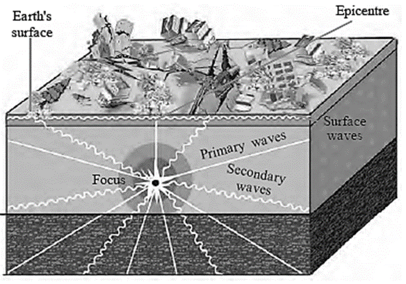
(b) Primary and Secondary Seismic Waves

Answer :

Primary Seismic Waves Secondary Seismic Waves
The seismic waves that reach the earth first, immediately after the energy is released in the interior are called primary seismic waves. The seismic waves that reach the earth after the primary seismic Waves are called secondary seismic waves.
Primary seismic waves can travel through all the three mediums i.e. liquid, solid and gaseous. Secondary seismic waves can travel only through the solid medium.
The particles lying in the way of primary seismic waves move to and fro in the direction of energy transfer. The particles lying in the way of secondary seismic waves move up and down in the direction of energy transfer.
Compared to secondary seismic waves, the primary seismic waves are less destructive. Compared to primary seismic waves, the secondary seismic waves are more destructive.

[collapse]

(c) Earthquakes and volcanoes

Answer :

Earthquakes Volcanoes
Sometimes, due to rapid earth movements below the surface, the crust is subjected to a tremendous stress. This energy gets released suddenly resulting in trembling of the surface of the earth. This sudden trembling of the earth’s surface is called an earthquake. A process in which hot solid, liquid and gaseous materials are thrown out of from the mantle of the earth onto the surface of the earth, is called volcanic eruption/volcanoes.
Due to earthquake, the land may not erupt or subside. Land may erupt or subside with a smaller extent. Due to volcanoes, the land erupts up to great extent and as a result cone shapes mountains or volcanic plateaus are formed.
During earthquake, molten magma may not come out on the surface of the earth. During volcanic eruption, molten magma comes out on the surface of the earth.

[collapse]

Question 6.

Answer in brief

(a) Give reasons why an earthquake occurs.

Answer :

An earthquake occurs due to the following reasons :

  • Tremendous tension is created in earth's crust due to internal movements.
  • The Plates move
  • The plates collide over each other.
  • Plates slides one below the other.
  • Fractures are formed in rock layers due to tension in the interior of the earth.
  • Sometimes volcanic eruptions occur.

[collapse]

(b) Which type of movements have led to the formation of the major fold mountains in the world?

Answer :

  • The effect of slow movements can be seen in the form of formation of mountains and continents.
  • Slow endogenetic movements that occur continuously have led to the formation of the major mountains in the world.
  • The major fold mountains like the Himalayas, the Aravalies, the Rockies, the Andes, the Alps, etc. are formed due to slow endogenetic (internal) movements.

[collapse]

(c) How is the magnitude of the earthquake related to the collapse of houses

Answer :

  • The high magnitude of the earthquake leads to the collapse of houses on a large scale. The secondary waves reach the earth’s surface after the primary waves are reached. These waves are more destructive than the primary waves.
  • The particles lying in the way of these waves move up and down in the direction of energy transfer. As its effect the houses on the earth’s surface move up and down and collapse.

[collapse]

(d) What are the effects of earthquakes on the earth’s surface and human life?

Answer :

(A) Effects on the earth’s surface :

  • Earthquake leads to formation of cracks/fractures on the ground.
  • It causes landslides which leads to sliding of rocks.
  • It sometimes leads to the change in the course of the groundwater.
  • It results in uplifting or subsiding of land.
  • It sometimes leads to generation of tsunamis in oceans.
  • It also leads to occurrence of avalanches in snow-covered areas.

(B) Effects on human life :

  • Earthquake leads to great loss of life and property.
  • It leads to disruption in transportation routes.
  • It leads to collapse of communication system.

[collapse]

(e) Explain the types of seismic waves.

Answer :

Seismic waves : The seismic waves can be divided into primary, secondary and surface waves as follows :

Primary or ‘P’ waves : These waves are the first one to reach the surface of the earth after the energy is emitted in the earth’s interior.

  • These waves travel from the focus of the earthquake in radial direction.
  • These waves are also called forward-backward waves.
  • These waves can travel through all the three states -liquid, solid and gases.

Secondary or ‘S’ waves : The waves which reach the earth’s surface after the primary waves are called secondary waves.

  • These waves also scatter in all direction from the focus of the earthquake.
  • Their velocity is lesser than ‘P’ waves.
  • These waves can travel only through solid medium.
  • These waves are more destructive than the ‘P’ waves.

Surface waves or ‘L’ waves : These waves are generated after the main ‘P’ waves and ‘S’ waves reach the epicenter.

  • They travel in the direction of the circumference of the earth along the crust.
  • They are highly destructive.

[collapse]

(f) Explain the types of volcanoes on the basis of periodicity of eruption with examples.

Answer :

Types of volcanoes on the basis of periodicity of eruption : The following are the types of volcanoes on the basis of periodicity of eruption :

  • Active volcanoes : If the volcanic eruptions are regular in the present times, then such volcanoe areas are called active volcanoes. For example, Mt Fujiyama in Japan, Mt. Stromboli in Mediterranean Sea.
  • Dormant volcanoes : When a volcano has not erupted since long, but may become active suddenly, it is called dormant volcano. For example, Mt. Vesuvius in Italy, Mt. Katmai in Alaska, Barren Island, India.
  • Extinct volcanoes : The volcanoes which have not erupted in the past since long and are not likely to erupt in the future are called extinct volcanoes. For example Mt. Kilimanjaro in Tanzania.

[collapse]

Question 7.

Show the epicentre, focus and the primary, secondary and surface waves of an earthquake with the help of a neat labelled diagram.

Answer :

***This type of questions are excluded in the revised pattern

[collapse]

Question 8.

Show the following on a given outline map of the world.

(a) Mt. Kilimanjaro

(b) Mid-Atlantic Earthquake zone

(c) Mt. Fuji

(d) Krakatoa

(e) Mt. Vesuvius

Answer :

Activity based, student should do it by self.

[collapse]

PDF-Notes, Solution, Text Book

    KitabCd Academy-Offer

      Buy Notes(Rs.5)+ Solution(Rs.5) PDF of this chapter with 20% discount
      Price : Rs.10 / Rs.8

      Click on below button to buy PDF in offer (20% discount)

    Click on link to get PDF from store

    MSBSHSE-Class 9-Geography-Chapter-2-Endogenetic Movements-Notes

    MSBSHSE-Class 9-Geography-Chapter-2-Endogenetic Movements-Solutions

    MSBSHSE-Class 9-Geography-Chapter-2-Endogenetic Movements-Text Book

    Useful links :


    Main Page : - Maharashtra Board Class 9th Geography  - All chapters notes, solutions, videos, test, pdf.

    Previous Chapter : Chapter 1: Distributional Maps - online Solution

    Next Chapter : Chapter 3: Exogenetic Processes Part-1 - online Solution