Notes
|
Topics to be Learn :
|
The Earth’s Shape and the Distribution of Sunrays :
- The sun's rays can cover more or less of the earth's surface because of the spherical form of the planet and the resulting curvature. The heat from the sun is therefore distributed unevenly as a result.
- The globe can be divided into torrid, temperate, and frigid zones as well as tropical, temperate, and polar regions based on the uneven distribution of temperature (heat).
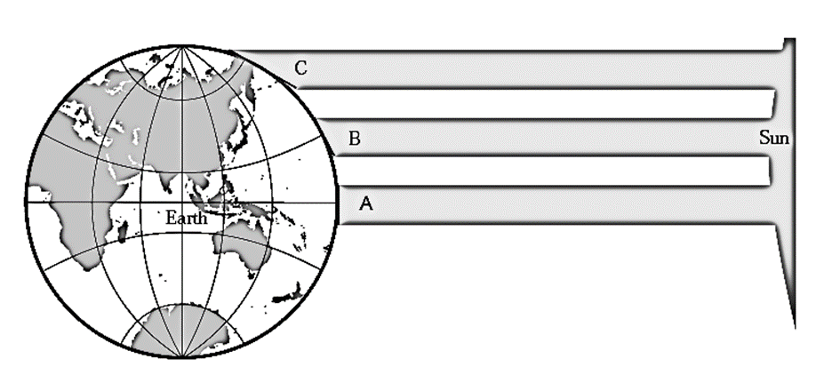
- The temperature will be high in the regions receiving perpendicular sunrays.
- The temperature will be moderate in the regions receiving slant sunrays.
- The temperature will be low in the regions receiving extremely slanting sunrays
Factors influencing the unequal distribution of temperature :
- Latitude is the main factor influencing the unequal distribution of temperature.
- Nearness to the sea, continentality, height above the mean sea level, physical set-up of the region, cloud cover, winds, vegetation cover, urbanization, industrialization, etc. are the other factors influencing the temperature and the local climate.
Temperature at different latitudes

Heating and cooling of land and water :
- The land heats up and cools down quickly; there is a difference in the time required for the heating and cooling of land and water. The water, on the other hand, warms up and cools down gradually.
- As its effect, in the continental areas (as compared to the coastal areas), the temperature of air is higher during the day but lower at night.
- On the other hand, in the coastal areas (as compared to the continental areas), the temperature of air is lower during the day but higher at night.
Ranges of temperature :
- The difference in the maximum and the minimum temperatures of a day is called diurnal range of temperature.
- The diurnal range is more in the continental areas. Therefore, in continental areas the climate is extreme. On the other hand, the diurnal range is less in the coastal areas. Therefore, in coastal areas the climate is equable.
- The difference in the mean temperature of summer and winter is called annual range of temperature.
Vertical distribution of temperature :
- As one moves higher up from the surface, the temperature of the air decreases.
- The temperature near the sea level is higher and it decreases in the mountainous regions.
Effects of greenhouse gases :
- Some gases in the atmosphere like carbon dioxide and water vapour can hold the heat within themselves for a long period of time.
- Due to these gases, the temperature of air in the atmosphere increases. This leads to global rise in temperature. (Global warming)
- The gases due to which the temperature increases are called Greenhouse Gases.
Ocean currents :
- Due to temperature differences, both upward and horizontal currents develop in ocean. Besides temperature differences, factors like winds and differences in the density of water also give rise to horizontal currents.
- The ocean currents flow from the equator to the polar regions and from the polar regions to the equator.
- Ocean currents bring changes in temperature of the coastal areas.
Isotherms :
- The lines that are drawn on a map joining the places of equal temperature on the earth are called isotherms.
- Isotherms generally appear parallel to the latitudes.
- The isotherms in the southern hemisphere are fairly parallel to the latitudes. In the northern hemisphere, the distance between isotherms varies leading to curved nature of these lines.
- Vegetation cover, urbanization, industrialization etc. leads to diversity in the distribution of temperature, these factors make the isotherms run zigzag over continental areas.
Thermometer :
- Different types of thermometers are used for measuring the temperature of the air.
- Mercury or alcohol is used in the thermometers as these materials are highly sensitive to temperature variations.
- Variations in temperature from —30°C to +55°C can easily be observed with the help of these materials.
- The difference in the daily temperature (maximum-minimum) can be observed with the help of a thermometer.