Solution
Question (A)
Select the correct option.
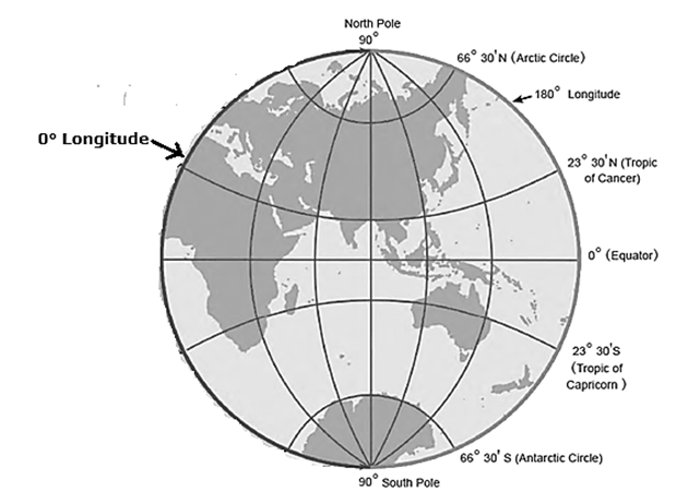
(1) 66° 30' North parallel means
(i) Arctic Circle (ii) Equator (iii) Antarctic Circle
(i) Arctic Circle
(2) Which parallel bisects the earth?
(i) Tropic of Cancer (ii) Tropic of Capricorn (iii) Equator
(iii) Equator
(3) What is the angular distance of the Arctic Circle from North Pole?
(i) 66° 30' (ii) 90° (iii) 23° 30'
(iii) 23° 30'
(4) Where do the Prime Meridian and the equator intersect each other?
(i) Southern Ocean (ii) Atlantic Ocean (iii) African Continent
(ii) Atlantic Ocean
(5) Up to which parallels from the equator can the sun’s rays be perpendicular?
(i) Tropic of Cancer and Tropic of Capricorn
(ii) Arctic and Antarctic Circles
(iii) North and South Poles
(i) Tropic of Cancer and Tropic of Capricorn
(6) What would be the latitude of a place on the South Pole?
(i) 90° S (ii) 90° N (iii) 0°
(i) 90° S
Question (B)
Read the following statements and correct the wrong ones.
(1) While describing the location of a place mentioning the meridian is sufficient.
Wrong. While describing the location of a place mentioning the meridian as well as parallels is essential.
(2) For describing the extent of a region, it is necessary to assume the latitude and longitude of the centre of the adjoining region.
Wrong. For describing the extent of a region, It is necessary to assume two latitudes and two longitudes at the extreme ends of the same region.
(3) Location of a road can be described only with a map.
Wrong. Location of a road can be described by a map as Well as by GIS, GPS, etc.
(4) 0° East meridian and 180° East meridian.
Wrong. 0° Meridian and 180° Meridian
(5) The extent of a road or a river course is described with the help of the latitude of a point in the source and the longitude of a point at the end.
Wrong. The extent of a road or a river course is described with the help of the latitude of a point as well as longitude of a point in the source and the longitude of a point as well as latitude of a point at the end.
(6) 8° 4' N parallel to 37° 66° N parallel is the correct description of a location.
Wrong. 8°4' N parallel to 37°66‘ N parallel is the incomplete description of a location as it expresses only a latitudinal spread of a location.
Question (C)
Find the locations of following cities from a world map, a map of India or a Globe and write down the latitude and longitude of each of them.
| (1) Mumbai
(2) Guwahati (3) Srinagar (4) Bhopal (5) Chennai |
(6) Ottawa
(7) Tokyo (8) Johannesburg (9) New York (10) London |
(1) Mumbai : 19° N latitude and 73° E longitude. (2) Guwahati : 26° N latitude and 91° E longitude. (3) Srinagar : 34° N latitude and 75° E longitude. (4) Bhopal : 23° N latitude and 77° E longitude. (5) Chennai : 13° N latitude and 80° E longitude. (6) Ottawa : 45° N latitude and 76° W longitude. (7) Tokyo : 36° N latitude and 140° E longitude. [8] Johannesburg : 26° S latitude and 28° E longitude (9) New York : 41° N latitude and 74° W longitude. (10) London : 52° N latitude and O°8' W longitude.
Question (D)
Find and write down the extent of the following. (Check them on the internet/mobile).
(1) Maharashtra (State)
16°03’ N latitude to 22° N latitude and 72° E longitude to 81° E longitude.
(2) Chile (A country)
16° S latitude to 56° S latitude and 70°40’ W longitude to 70° W longitude.
(3) Australia (A continent)
10°41‘ S latitude to 43°38’ S latitude and 113°09' E longitude to 153°38' E longitude.
(4) Sri Lanka (An island)
6°48‘ N latitude to 9°50‘ N latitude and 79°40‘ E longitude to 81°45‘ E longitude.
(5) Trans Siberian Railway of Russia (Starting point - St. Petersburg, Terminal Point-Vladivostok)
From 59° N latitude and 30° E longitude To 43° N latitude and 132° E longitude.
Question (E)
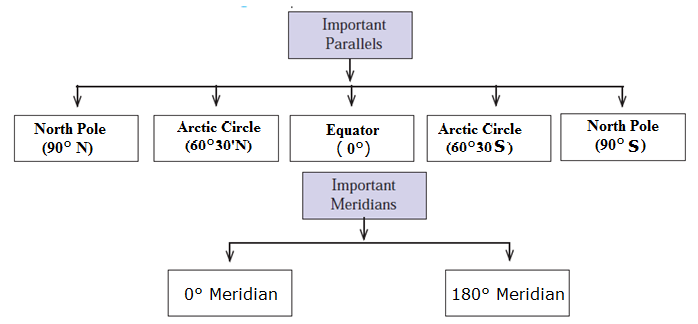
Draw important parallels and meridians in the figure given below and label them with appropriate angular measures. (Use the protractor.)

Question (F)
Write the important parallels and meridians in the following table: