Solutions-Class-7-Geography-Chapter-11-Contour Maps and Land forms-Maharashtra Board

Contour Maps and Land forms

Maharashtra Board-Class-7th-Geography-Chapter-11

Solutions

Question 1. Answer the following questions.

(1) How can the distribution of the height and landforms in a region be shown?

Answer :

The distribution of the height and landforms in a region can be shown with the help of contour maps.

(2) To whom are the contour maps useful?

Answer :

The contour maps are useful to mountaineers, trekkers, farmers, soldiers, defense officers, etc.

(3) What do you understand by observing contour lines?

Answer :

By examining contour lines, one may learn the following:

  • The altitude of a certain location in relation to sea level.
  • The type and direction of a certain location's slope.
  • Locations in a certain region with the same height.

(4) How will a contour map be useful for a farmer?

Answer :

The contour map will be useful for a famer in the following ways :

  • To select a particular low-lying land for intensive farming.
  • To select a particular hilly tract for practising plantation farming.
  • To study the slope of land and to anticipate the velocity of water running along the slopes.

Question 2. Fill the blanks with appropriate words.

(1) If the contour lines are closer to each other, the slope is ...............

Answer :

Steeper

(2) The contour lines on the map represent ...............

Answer :

Places of same altitude

(3) The slope can be understood from the distance between the ...............

Answer :

Contour lines

(4) If the distance between two contour lines is more, the ............... is gentle.

Answer :

Slope

Question 3. Identify the landforms in the following map.

Answer :

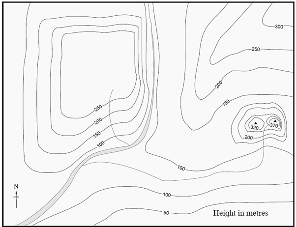
The following landforms are shown in the above map :

(1) Plains (2) Mountainous region (3) Peak.

PDF-Notes, Solution, Text Book

Click on below link to get PDF from store

Rs 7

-Kitabcd Academy Offer-

To Buy Notes(Rs.5)+ Solution(Rs.5) PDF of this chapter
Price : Rs.10 / Rs.7

Click on below button to buy PDF in offer (30% discount)

MSBSHSE-Class-7-Geography-Chapter-11-Contour Maps and Land forms-Notes

MSBSHSE-Class-7-Geography-Chapter-11-Contour Maps and Land forms-Solutions

MSBSHSE-Class-7-Geography-Chapter-11-Contour Maps and Land forms-Text Book


All Chapter Class-7-Geography Notes Set (11-PDF) Rs. 35-Buy

All Chapter Class-7-Geogarphy Solutions Set (10-PDF) Rs. 28-Buy

All Chapter Class-7-Geogarphy Notes + Solutions Set (21-PDF) Rs. 55-Buy

All Notes -Social Science  (History_Civic+Geography-30-PDF) Rs. 80-Buy

All Solutions -Social Science  (History_Civic+Geography-29-PDF) Rs. 72-Buy

All Notes + Solutions -Social Science  (History_Civic+Geography-59-PDF) Rs. 135-Buy

Useful links for Class 7


Main Page : Class 7th MSBSHSE – Geography - All chapters notes, solutions, videos, test, pdf.

Previous Chapter : Chapter 10 : Human Settlements - Online Solutions


Leave a Reply

Leave you Replay.... Your email address will not be published. Required fields are marked *