Solutions
Question 1.
(a) Classify maps showing the following areas into small scale or large scale
(1) Building, (2) School, (3) Country of India, (4) Church, (5) Mall, (6) World Map (7) Garden, (8) Dispensary, (9) Maharashtra State, (10) The north sky at night
The classification of maps showing the given areas is as follows :
(b) There are two maps with respective scales of 1cm = 100m and 1cm = 100 km. Give a well reasoned answer as to which of then would be a large scale map and which a small scale map. Recognize the type of maps.
Out of the two maps with respective scales of 1 cm = 100 m and 1 cm = 100 km, a map with respective scale of 1 cm = 100 m would be a large scale map. Reasons : Types of maps :
Question 2. Using a map of India from the atlas measure straight line distance between the following cities and complete the table below.
| Cities | Distance on map | Actual Distance |
| Mumbai to Bengaluru | ............. | ----km |
| Vijaypura to Jaipur | ............. | ----km |
| Hyderabad to Surat | ............. | ----km |
| Ujjain to Shimla | ............. | ----km |
| Patna to Raipur | ............. | ----km |
| Delhi to Kolkata | ............. | ----km |
Cities
Distance on map
Actual Distance
Mumbai to Bengaluru
0.98 cm
980 km
Vijaypura to Jaipur
2 cm
2000 km
Hyderabad to Surat
0.9 cm
900 km
Ujjain to Shimla
1.14 cm
1140 km
Patna to Raipur
0.75 cm
750 km
Delhi to Kolkata
1 cm
1000 km
Question 3.
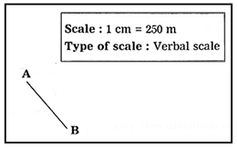
(a) The distance between two points A and B on the Ground is 500m. Show this distance on paper by a line of 2cm. Express the map scale by any one method and mention it.
(b) Convert verbal scale of 1cm = 53km to a numerical scale
(c) Convert the numerical scale of 1:10,000 000 to a verbal scale in the metric system.
Question 4. Help them, using road and railway maps of the state of Maharashtra. Use the scale given in the maps.
It is activity based question, student should do it by self